Branch Lines
The TRA operates/operated twelve branch lines, which are/were branching off the ring line. Six of them are closed and mostly dismantled (Tamsui, Xindian, Donggang, Shenggang, Dongshi and Linkou Line), the other six remain fully or partly in operation (Neiwan, Pinxi, Shen'ao, Jiji, Shalun and Liujia Line). This figure does not count non-governmental lines, which branched off at many stations like forest or sugar railways (see Forest Railways or Sugar Railways for details), or short governmental lines which were considered as sidings (see Sidings for details).
The branch lines usually lead only a few kilometres inland or to ports on the coast. The first branch line was the Tamsui Line, which connected the port at Tamsui with Taipei. Other branch lines connected coal mines to the governmental railway network and were initially built and operated by private companies, before they were taken over by the government (Xindian and Pinxi Line). The Jiji line, initially built for the construction of a large hydropower dam, was also taken over by the government at a later stage. The Donggang and Neiwan Line were built during WWII for strategic reasons (the Neiwan Line was only opened after the war). After the war, additional branch lines were mainly built to connect newly built coal plants along the coast line with the railway network (Shen’ao and Linkou Line). As most of the branch lines were mainly used for goods traffic, they lost most of their traffic with the decline of goods transports on the railways, which already started in the 1960s. Only growing tourist traffic helped some branch lines to survive, the others were closed until the 1990s. Recently, the TRA opened two new short branch lines (Shalun and Liujia Line) to connect high speed railway stations, which are lying far away from the city centres) with its railway network.
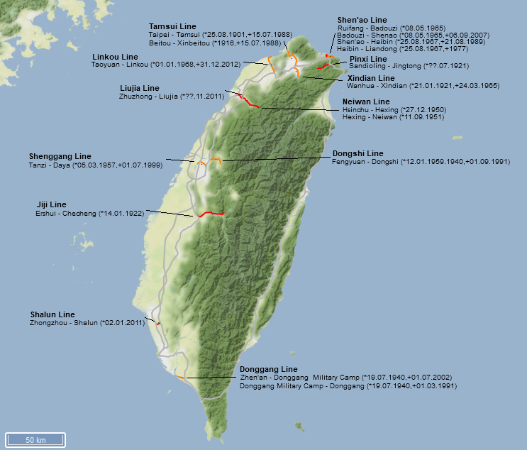 Figure 1: This map shows all branch lines of the TRA in red (in operation) and orange (closed/dismantled) with their opening and closing dates. The TRA ring line and the high speed line are marked in grey (Terrain by Stamen.com)
The different branch lines are described in more detail below. Please click on the headings to expand the areas.
Tamsui Line
Ten years after the opening of the first public Chinese railway line between Keelung and Taipei (Twatutia station), a 21.2 km branch line along the Tamsui (Danshui) River to the port at the mouth of the sea was opened in June 1901. The line served both passenger and freight traffic, in particular department stores, refineries and port facilities were connected via sidings. In order to better connect the hot springs at Beitou for visitors from Taipei, a 1.2 km short branch line was built from Beitou station to Xinbeitou station in 1916.
However, the port silted up relatively quickly and freight traffic fell sharply. Thanks to the meanwhile high number of passengers, the line remained in operation. During the war, the strategically unimportant branch to Xinbeitou was dismantled, but rebuilt in 1946. The construction of a parallel expressway in the 1960s then led to a sharp drop in passenger numbers. It was finally decided to close the at the beginning of the 1980s. There were three options for usage of the idle track bed: expand the road, setting up a dedicated bus lane or converting it into a metro line. The choice finally fell on option three. The old line remained in operation until July 15, 1988, then it was shut down and replaced by the new Tamsui metro line (Red line, line 1), which opened on March 28, 1997 and largely follows the old route, but partly underground, partly on stilts. The short branch line to Xinbeitou has also become part of the metro line.
 Figure 2: Map of the Tamsui Line including the short branch to Xinbeitou with opening and closing dates (Terrain by Stamen.com)
| From | To | Length (km) | Opening / Closing Year | Remark |
| Taipei (台北) | Tamsui (淡水) | 21.2 | 1901 | public transport opened on 25.08.1901 |
| Beitou (北投) | Xinbeitou (新北投) | 1.2 | 1916 | line was dismantled during the war (1944?) and rebuilt in 1946 |
| Taipei (台北) | Tamsui (淡水) | 21.2 | 1988 | closed on 15.07.1988, large parts of track bed reused for metro line 1 (red line) on stilts |
| Beitou (北投) | Xinbeitou (新北投) | 1.2 | 1988 | closed on 15.07.1988, large parts of track bed reused for metro line 1 (red line) on stilts |
| 22.4 |
 Figure 3: This historic photograph was taken during the Japanese occupation period. As seen, the passenger demand was high. On weekdays commuters used the trains whereas on week ends the trains mainly transported excursionist visiting the beaches or the hot springs (李火增, Public domain, via Wikimedia Commons)
.jpg) Figure 4: Today large sections of the Tamsui Metro Line run on the former tracks of the Tamsui Line (billy1125 from Hualien, Taiwan, CC BY 2.0
Figure 4: Today large sections of the Tamsui Metro Line run on the former tracks of the Tamsui Line (billy1125 from Hualien, Taiwan, CC BY 2.0
During the Japanese occupation era, several coal mines were opened in the mountains south of Taipei. In order to simplify the transport of the coal, the private "Taiwan Railway Company" was founded, which opened a 10.4 km long branch line from Wanhua station at the governmental Western Line at the southern city gate of Taipei to the foot of the mountains, where two mine railways in 762mm gauge connected. The line was opened on January 21, 1921. Initially only intended for coal transport, the line also quickly enjoyed increasing demand for passenger transport which was introduced shortly after the opening of the line. During workdays, the line was used by commuters and on weekends, excursionists from Taipei used the trains to visit the mountains with its hot springs.
After the war, the railway was taken over by the governmental TRA. The construction of a parallel road in the mid-1950s caused passenger numbers to collapse and the few remaining coal mines shifted their transports to the Zhonghe siding line (see Sidings, which opened in 1965. The Xindian line was closed on March 24, 1965; only a short section at Wanhua station was used as a siding until 1968. In 1970 the tracks were dismantled and the track body was completely built over or used for road expansion. Today's metro line 3 (Green Line) of the MRT Taipei runs in large parts on exactly the same route as the Xindian Line, but mostly underground.
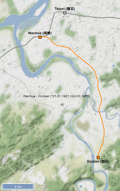 Figure 5: Map of the Xindian Line with opening and closing dates (Terrain by Stamen.com)
| From | To | Length (km) | Opening / Closing Year | Remark |
| Wanhua (萬華) | Xindian (新店) | 10.4 | 1921 | intially opened in 22.01.1921 as a private line for a coal mine. Taken over by the Government Railway after the war. |
| Wanhua (萬華) | Xindian (新店) | 10.4 | 1965 | line closed on 24.03.1965 |
| 10.4 |
 Figure 6: This historic photograph dated from the 1930s shows a train on the Xindian Line which was then still belonged to a private company. It was only taken over by the government railways after WWII (洪長庚, Public domain, via Wikimedia Commons)
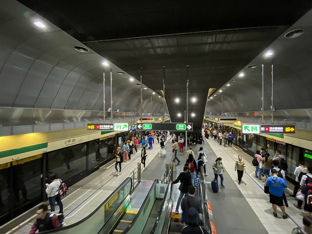 Figure 7: In 1965, the Xindian Line was closed. Nowadays there is another Xindian Line which is part of Taipei's metro system. It follows more or less the old line, howver largely underground as seen here at Zongshan station (Wpcpey, CC BY 4.0
The mountains southeast of Taipei contain extensive coal deposits, which were already exploited before the Japanese occupation. The Japanese intensified the coal mining in the Pinxi valley and connected the mines with a pushcart line over the mountains to Taipei. The opening of the Yilan Line (see Main Lines offered the chance to directly connect the Pinxi valley with the governmental railway network. The private company "Taipei Charcoal Co., Ltd.", which operated some coal mines in the valley, decided to build a 12.9 km long branch line into the valley, which branched off at Sandiaoling on the Yilan Line. However, due to the global economic crisis, the company went bankrupt and was taken over by "Taiyang Mining Co., Ltd.", which continued the construction. The entire line could finally be opened in July 1921. Initially, the railway was limited to the transport of coal, which led to increasing discontent among the local population, so that the railway was finally taken over by the governmental railway on October 1, 1929, which then immediately introduced passenger and additional goods traffic (agricultural products, wood).
Even though the linear distance between end point of the Pinxi Line at Jingtong and Taipei is rather short, the pushcart lines were not used anymore as several mountain ranges had to be crossed. Thus, trains to Taipei had to take a more than 50 km long detour. Both before and after the Second World War, there were repeated plans to extend the route from Jingtong to Xindian at the end of the Xindian Line by crossing the mountain ranges, but all of them (most recently in 2017) were discarded due to the high costs caused by the geographical difficulties. In the late 1980s, the last mines closed and the villages along the way saw a sharp decline in population. The line was also due to be closed, but was able to hold on thanks to the meanwhile strong increase in tourist and day trip traffic. The Pinxi Line is marketed for tourism, especially because of the beautiful nature and the narrow village passages; in 2016, around 1.1 million passengers used the route. With the partial re-opening of the Shen’ao Line (see below), there are now direct trains between the two end points of the Pinxi and Shen’ao Line. The trains use the Yilan Line between Sandiaoling and Ruifang.
 Figure 8: Map of the Pinxi Line with opening dates. The Pinxi Line branches off from the Yilan Line (part of the ring line) at Sandioaling station and runs through a valley to a former coal mine in Jingtong. Today there is practically only tourist traffic. The diesel trains on the Pinxi Line are now tied through with the remainder of the Shen’ao Line, i.e. the trains run between Jingtong and Badouzi, with the Yilan Line being used between Sandiaoling and Ruifang. (Terrain by Stamen.com)
| From | To | Length (km) | Opening Year | Remark |
| Sandiaoling (三貂嶺) | Jingtong (菁桐) | 12.9 | 1921 | opened in July 1921 by Taiyang Mining Co., Ltd.; taken over by Government Railways on 01.10.1929 |
| 12.9 |
Heino Vogel, a German railway enthusiast, has published photos and a video of the Pinxi Line.
 Figure 9: Shifen station is the most important station on the Pinxi Line (photo by ChangIc in Wikimedia Commons).
 Figure 10: Historic photo of Shifen station dated from 1992 (photo by Thyristorchopper / CC BY-SA (https://creativecommons.org/licenses/by-sa/3.0) in Wikimedia Commons)
 Figure 11: The Pinxi Line runs directly though the narrow roads of Shifen (Photo by ChangIc in Wikimedia Commons).
 Figure 12: Bridge over the Sangkeng River (Photo by Xingengjiwu / CC BY-SA (https://creativecommons.org/licenses/by-sa/4.0) in Wikimedia Commons).
The almost 30 km long Jiji Line was originally laid out in the early 1920s by the state-owned power company "Taiwan Power Co., Ltd." to build a dam and hydroelectric power plant near Checheng (Mingtan Pumped Storage Hydro Power Plant on Sun Moon Lake), the official opening took place on January 14, 1922. Most probably, the line was initially built in 762mm gauge, but re-gauged soon after the opening except a short stretch near the dam at the end of the line. After the construction of the dam and the power station were completed, the government acquired the line in May 1927 and established regular passenger traffic. The line has several tunnels whose clearance profile did not correspond to the standard profile of the rest of the railway network. Therefore, only special locomotive trains with a small clearance profile could run on the line.
On September 21, 1999, one of the worst earthquakes in Taiwan's history (7.3 on the Richter scale, 2,415 deaths) severely damaged the line as the epicentre was only a few kilometres away from the railway line. The line was reopened on January 21, 2001, the tunnels were expanded to the standard clearance profile, and since then the standard TRA rolling stock can be used on the line. The line is mainly used by tourists, Sun Moon Lake is one of the main attractions of Taiwan. Twelve pairs of trains run on the route every day; in 2016, an average of 1,712 passengers used the trains per day.
 Figure 13: Map of the Jiji Line. The Jiji Line was laid out in 1922 for the construction of a hydroelectric power station near Checheng and was later taken over by the state railway. It branches off from the Western Line (part of the ring line) in Ersui. Today the route is only important for excursion and tourist traffic (Terrain by Stamen.com)
| From | To | Length (km) | Opening Year | Remark |
| Ershui (二水) | Checheng (車埕) | 29.7 | 1922 | opened 14.01.1922 by Taiwan Power Co., Ltd.; taken over by Government Railways in May 1927 |
| 29.7 |
Heino Vogel, a German railway enthusiast, has published photos and a video of the Jiji Line.
 Figure 14: A train on the Jiji Line near Longquan (photo by Cassiopeia sweet / Public domain in Wikimedia Commons).
 Figure 15: Checheng station (photo by Eeveelugia / CC BY-SA (https://creativecommons.org/licenses/by-sa/3.0) in Wikimedia Commons).
.jpg) Figure 16: Jiji station (photo by Adonis Lin / CC BY (https://creativecommons.org/licenses/by/3.0) in Wikimedia Commons).
Figure 16: Jiji station (photo by Adonis Lin / CC BY (https://creativecommons.org/licenses/by/3.0) in Wikimedia Commons).
The 6.2 km long Donggang Line in the southeast of Kaohsiung connected the port in Donggang with the Pingtung Line in Zhen’an. It was constructed for military reasons and opened on July 19, 1940. After the war, the line remained in service. However, after the opening of a road bridge over the river mouth of the Gaoping River in Donggang, there was a direct route to Kaohsiung without a detour via Pingtung and passenger numbers on the line plummeted. In the end, the passenger trains carried less than 60 passengers per day. On March 1st, 1991, passenger traffic on the line completely ceased and the last almost 3km section was dismantled and converted into a cycle path. The remaining section was still in use for military transports to a training camp of the Taiwanese army until July 1, 2002. Since then, the line is without any traffic. As part of the electrification of the Pingtung Line, the connecting switch at Zhen’an station was removed. In 2016, a feasibility study for resuming operations was carried out, but reactivation seems out of sight.
 Figure 17: Map of the Donggang Line with opening and closing dates. The rather short Donggang Line was built by the Japanese military for strategic reasons during World War II. In Zhen’an it branches off from the Pingtung Line (part of the ring line) and after a short arc runs almost always straight ahead. After the construction of a road bridge over the river in Donggang, passenger traffic on the route was stopped, only the military used a section until 2002. The line has been closed since then (Terrain by Stamen.com)
| From | To | Length (km) | Opening / Closing Year | Remark |
| Zhen'an (鎮安) | Donggang (東港) | 6.2 | 1940 | opened for traffic 19.07.1940 |
| Military Camp | Donggang (東港) | 2.6 | 1991 | closed 01.03.1991, afterwards dismantled and converted in a bicycle path, re-opening under discussion |
| Zhen'an (鎮安) | Military camp | 3.6 | 2002 | closed,track still in place, re-opening under discussion |
| 6.2 |
 Figure 18: The rails of the former Donggang Line still largely lie in place as the line was only closed in 2002. A study for the reopening of the line has been conducted, but there are currently no plans for an execution (Shih-Han Lin, CC BY 2.0
The construction of the Neiwan Line began in 1944 under the leadership of the Japanese occupiers to exploit mineral resources (especially limestone and coal) and wood from the mountains around Neiwan. Due to the war, however, work quickly came to a standstill. After the war, work was resumed and on December 27, 1950 the section from Hsinchu to Shifenliao / Hexing was officially opened, the extension to the coal mine in Neiwan was finally put into operation on September 11, 1951. The Neiwan Line was thus the first new line opened by the Taiwan Railway Administration (TRA).
Freight traffic already fell sharply in the 1960s, while at the same time commuter traffic to Hsinchu increased steadily in the lower section of the route; the upper section saw more and more tourists and excursionists. The increasing passenger traffic prevented a closure of the line. Especially on weekends, the TRA even offered direct trains from Taipei to Neiwan. During the construction of the high-speed line from Taipei to Kaohsiung, the large city of Hsinchu was bypassed relatively far as the Hsinchu high-speed line train station is more than 10 km outside of the city centre of Hsinchu. In order to connect the high-speed line train station to the city centre, the Liujia Line (see below) was built in 2011 to create a direct connection in from the high-speed line train station to Hsinchu main train on the governmental cape gauge network. As part of the construction works, the Neiwan line’s section from Hsinchu to Zhuzhong was electrified and double-tracked. At Zhuzhong, the 3.1km long Liujia Line branches off to the high-speed station Liujia. The Neiwan Line was closed for almost five years during the construction works. The upper section of the Neiwan Line from Zhuzhong to Neiwan remains single-tracked without electric wire. Only a few diesel trains, especially during mornings and evenings as well as on weekends, run continuously on the entire section from Hsinchu to Neiwan. All other trains commute between Hsinchu and Liujia, and those who want to continue in the direction of Neiwan have to change trains in Zhuzhong.
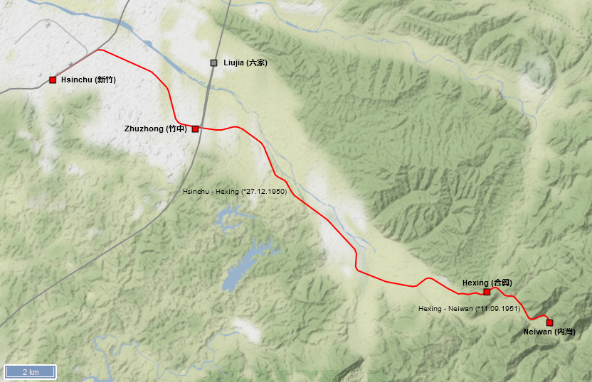 Figure 19: Map of the Neiwan Line with opening dates. The Neiwan Line was once built to connect coal mines and limestone quarries in the mountains east of Hsinchu. Construction began by the Japanese during the Second World War, but the line was not completed until after the war. Today, the line that branches off the Western Line (part of the ring line) in Hsinchu is only of greater importance for excursion and tourist traffic. Since 2011, the short Liujia Line has been branching off in Zhuzhong to connect the remote Liujia high-speed train station to the city of Hsinchu. The Hsinchu - Zhuzhong section of the Neiwan Line was expanded to two-track and electrified. (Terrain by Stamen.com)
| From | To | Length (km) | Opening Year | Remark |
| Hsinchu (新竹) | Hexing (合興) | 24.4 | 1950 | opened on 27.12.1950 |
| Hexing (合興) | Neiwan (內灣) | 3.5 | 1951 | opened on 11.09.1951 |
| 27.9 |
Heino Vogel, a German railway enthusiast, has published photos and a video of the Neiwan Line.
 Figure 20: Neiwan station (photo by Night Tracks at the English language Wikipedia / CC BY-SA (http://creativecommons.org/licenses/by-sa/3.0/) in Wikimedia Commons)
 Figure 21: Railcar DR2705 runs as a special train on the Neiwan Line (The original uploader was Chou0416 at Chinese Wikipedia., CC BY-SA 3.0
The Shenggang Line was opened on March 5, 1957 to connect a large material store and oil depot of the Taiwanese armed forces to the rail network. The line officially belonged to the army, but it was maintained and operated by the state railway. During the Vietnam War, the US Army made extensive use of the camp and the railway line. Later, the transports of the army were shifted more and more to the road and traffic on the line finally ceased. It was officially closed on July 1, 1999 and has now largely been converted into a cycle path..
 Figure 22: Map of the Shenggang Line with opening and closing dates. The Shenggang Line was built in 1957 to connect a large military camp to the rest of the route network. The army stopped rail transport in 1999, and the route has now been largely dismantled and converted into a cycle path. (Terrain by Stamen.com)
| From | To | Length (km) | Opening / Closing Year | Remark |
| Tanzi (潭子) | Oil depot | 13.4 | 1957 | officially opened on 05.03.1957; the line belonged to the army, but was maintained and operated by the TRA |
| Tanzi (潭子) | Oil depot | 13.4 | 1999 | closed and transformed into cycle path |
| 13.4 |
 Figure 23: Large parts of the former Shenggang Line have been converted into a cycle path (Fcuk1203, CC BY-SA 3.0
The Dongshi Valley east of Taichung saw its first railway in 1913, when the Taichung Light Railway opened a push-cart line into the valley. With the opening of the Baxianshan Forest Railway, the push-cart line was transformed into a 762mm line operated with steam locomotives (see Baxianshan Forest Railway under sub item Forest Railways). After the war, the railway was taken over by the governmental forestry bureau. The government wanted to expand the forest industry and also intended to build hydro power plants in the mountains as well as a road from Taichung to Hualien on the east coast that would cross the mountain range. In order to facilitate the construction works, the government took over the lower section of the forest railway between Puzi and Meitsi, re-gauged it to cape gauge and expanded the line further into the valley to Dongshi. This 14.7km long line that branched off at Fengyuan station on the Mountain/Taichung Line was opened on January 1st, 1959 (other sources mention the year 1956).
At the end of the 1950s, the forest industry started to decline and timber transports on the line ceased quite soon after the opening of the line until the finally ended in 1973. Initially, the growing number of commuters to Taichung helped the line to survive. However, the passenger numbers dropped sharply after the opening of a parallel road. Only students continued to use the line. Thus, the line was finally closed on October 1st, 1991 after having been in operations for less than 32 years! The tracks were removed and the route was converted into a cycle path.
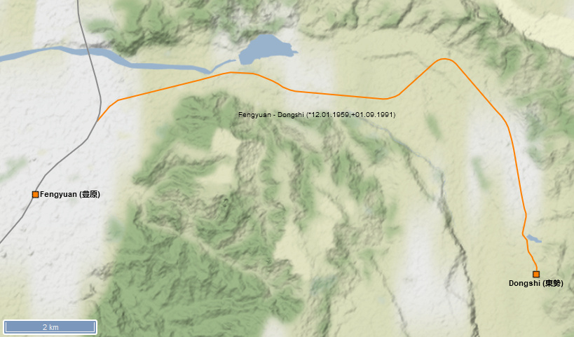 Figure 24: Map of the Dongshi Line with opening and closing dates. The Dongshi Line was built in 1959 (or 1956 as per some sources) to connect the forest industry in the valley as well as to build a hydroelectric power station and a road across the mountains to the east coast. The line branches off in Fengyuan north of Taichung and follows a river valley into the mountains. Freight traffic soon became meaningless and the route was only used by commuters and students to Taichung until it was shut down in 1991. A cycle path now runs along large parts of the former route. (Terrain by Stamen.com)
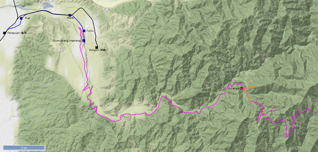 Figure 25: This map shows the Dongshi Line (marked in black) alongside the forest railways, which existed before the construction of the Dongshi Line. The line marked in blue shows the former section of the Taichung Light Railway, which was later partly used for the construction of the Dongshi Line; the line marked in pink shows the former Baxianshan Forest Railway (Terrain by Stamen.com)
| From | To | Length (km) | Opening / Closing Year | Remark |
| Fengyuan (豐原) | Dongshi (東勢) | 14.7 | 1959 | officially opened 12.01.1959 (some sources mention 1956 as opening year) |
| Fengyuan (豐原) | Dongshi (東勢) | 14.7 | 1991 | officially closed in 01.09.1991 and transformed into a cycle path |
| 14.7 |
 Figure 26: Official opening ceremony of Dongshi station on January 12th 1959 (Unknown author, Public domain, via Wikimedia Commons)
.jpg) Figure 27: A long bridge is the only remarkable point of the rather simple Dongshi branch line (Jaymyang, CC BY-SA 4.0
Figure 27: A long bridge is the only remarkable point of the rather simple Dongshi branch line (Jaymyang, CC BY-SA 4.0  Figure 28: Meitsi station in 1991 shortly before the closure of the Dongshi Line. For a short time, the Forest Railway to Banxianshan ended at this station (Jaymyang, CC BY-SA 3.0
  Figure 29: Dongshi station in 1991 just before the closure of the line (Jaymyang, CC BY-SA 4.0
The Shen’ao Line is quite short with originally 12.3 km in length, but it has a turbulent past behind it. A predecessor line in 762mm along the coast northeast of Keelung had existed since 1906. It mainly connected the gold and coal mines along the coast with the port at Keelung, but also offered regular passenger traffic. It was a private railway built and operated by Nippon Mining Co., Ltd. . After the end of the Japanese occupation, the railway was taken over by the Taiwan Metal Mining Co., Ltd., which finally shut down the railway on August 26, 1962.
Since the construction of a large coal-fired power station was planned in Shen’ao, the governmental TRA built a new line in cape gauge, which partly followed the route of the former mining railway. The starting point was no longer the port at Keelung, but the Ruifang station on the Yilan Line. The 6.4 km long section to Badouzi, including a 1.3 km siding to the coal-fired power station, was opened on 8 May 1965. About two years later, the line was extended by 7.6 km along the coast line to Liandong, where two major tourist attractions ("Shuina Cave" and the "Golden Waterfall") are situated. The extension was not in operation for a very long time, however. On July 1, 1977, after just twelve years of operations, the section was closed as it stood in the way of expanding the coastal road. Only the section to Haibin re-opened after construction works on the road were finished. Most tourists used busses or cars to travel to Liandong. Thus, on August 21, 1989, all passenger traffic on the line finally ended. Only coal transport to the power plant in Shen’ao remained on the railway line. However, this also ended on September 6, 2007 with the shutdown of the power plant. Since the construction of a large marine science museum ("National Marine Science and Technology Museum") was planned near the former power station, the route was not dismantled with foresight. Instead, a new stop was set up at the museum and on 9 January 2014 passenger traffic on the Shen’ao Line up to Badouzi resumed. The diesel trains on the line commute between Badouzi and Jingtong (terminus on the Pinxi Line) by using the Ruifang - Sandiaoling section of the Yilan Line in between.
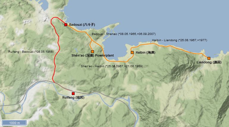 Figure 30: Map of the Shen'ao Line with opening and closing dates. The Shen‘ao Line has a rather turbulent past. The gold and coal mines along the coast east of Keelung had been connected to the Keelung port by a 762mm private railway since 1906. The private railway was shut down in 1962, and in 1965 the state railway opened a branch line in cape gauge to connect a coal-fired power plant in Shen'ao, which branched off from the Yilan Line (part of the ring line) at Ruifang and not at Keelung port as the old mining railway. Two years later the route was extended along the coast to Liandong. But just ten years later, the railway had to largely give way to the expansion of the coastal road. The coal-fired power plant was operated until 2007, after which the remaining section Ruifang - Shen’ao was shut down. In 2014, the section Ruifang - Badouzi was reactivated in passenger traffic (Terrain by Stamen.com)
| From | To | Length (km) | Opening / Closing Year | Remark |
| Ruifang (瑞芳) | Shen'ao (深澳) | 6.4 | 1965 | official opened on 08.05.1965 to connect the coal power plant at Shen'ao |
| Shen'ao (深澳) | Liandong (簾洞) | 6.3 | 1967 | official opened on 25.08.1967 |
| Haibin (海濱) | Liandong (簾洞) | 3.7 | 1977 | closed to give way for construction of coastal road |
| Shen'ao (深澳) | Haibin (海濱) | 2.6 | 1989 | officially closed 21.08.1989 and dismantled; already out of service during construction of coastal road around 1977 |
| Ruifang (瑞芳) | Shen'ao (深澳) | 6.4 | 2007 | line closed on 06.09.2007 after shut down of coal power plant at Shen'ao |
| Ruifang (瑞芳) | Badouzi (八斗子) | 4.6 | 2014 | re-opening on 09.01.2014 of section closed in 2007 |
| 12.7 |
 Figure 31: A coal train on the Shen'ao Line shortly before its closure in 2007 (Kutrain, CC BY-SA 3.0 [creativecommons.org], via Wikimedia Commons)
 Figure 32: A tunnel on the former section of the Shen'ao Line near Liandong. This part of the Sne'ao Line only sawten years of operations (M940504, CC BY-SA 4.0
The 18.4 km long Linkou Line was opened on January 1, 1968 to connect a large coal-fired power station on the coast near Taoyuan to the railway network. In addition, other industrial companies along the route also received a rail connection. For a long time, the line remained a pure freight connection route. Only on October 27, 2005 passenger traffic on the route started after several large housing estates had emerged along the line. With the construction of a new large international airport for Taipei (Chiang Kai Shek Airport) close to the line, there were even plans to double-track and electrify the line to handle metro trains to the airport. To do this, however, the main line between Taoyuan and Taipei would have had to be expanded to include three or four tracks. Therefore, it was decided to build a separate MRT line from the main train station in Taipei to the airport (see Metro Lines). Even before the completion of the Airport MRT, passenger traffic on the Linkou Line ceased on December 28, 2012, only seven years after its opening. Freight traffic followed three days later. The reason for the closure was that the Western/Trunk Line was put underground within the Taoyuan area, whereby the connection of the branch line was omitted. Coal supply of the power plant is carried out by ships, which land the coal mainly imported from Australia, directly at the power plant port. The railway line has now been partly converted into a cycle path.
 Figure 33: Map of the Linkou Line with opening and closing dates. The Linkou Line was built in 1968 to connect a new coal-fired power station on the coast north of Taoyuan. It branched off at Taoyuan Station and ran largely straight to the coast, where it then turned to the east. Passenger traffic was also carried out between 2005 and 2012, although this had to be stopped when construction work began to lower Taoyuan station. Freight traffic followed shortly thereafter. Since then, the line has been shut down and can no longer be reached from the rest of the network (Terrain by Stamen.com)
| From | To | Length (km) | Opening / Closing Year | Remark |
| Taoyuan (桃園) | Linkou (林口) | 18.4 | 1968 | opened on 01.01.1968 to connect coal power plant |
| Taoyuan (桃園) | Linkou (林口) | 18.4 | 2012 | closed on 31.12.2012 as Taoyuan station was put underground |
| 18.4 |
 Figure 34: Passenger traffic on the Linkou Line in 2007 (photo by I, SElefant / CC BY-SA (http://creativecommons.org/licenses/by-sa/3.0/) in Wikimedia Commons)
 Figure 35: The Linkou Line branches off the Western Line at Taoyuan station. When the Western Line was put underground in the Taoyuan area in 2012, the Linkou Line lost ists connection to the railway network and was thus closed (Honmingjun, CC BY-SA 3.0
  Figure 36: The Linkou Line was initially built to serve a coal power plant on the coast line. This picture shows the end of the line after the closure in 2012 (Honmingjun, CC BY-SA 3.0
  Figure 37: In addition to the coal power plant, the line also served other industrial estates near Taoyuan (Honmingjun, CC BY-SA 3.0
  Figure 38: Initially, the Linkou Line was built for freight traffic only. In 2005, passenger services were intorduced. However, this did not save the line and it was closed in 2012 (Honmingjun, CC BY-SA 3.0
The Tainan station on the high-speed line, which opened in 2007, is far away from the urban area and the Tainan station on the conventional rail line. Therefore, on January 2, 2011, a short branch line from Zhongzhou Station to Shalun Station on the high-speed line was opened to enable passengers in Tainan to easily switch from the conventional TRA network to the THSRC high-speed line. The double-tracked line was built in cape gauge, is electrified and mostly runs on bridges.
 Figure 39: Map of the Shalun Line with opening dates. The Shalun Line has been connecting the remote Shalun high-speed station to the governmental railway network since 2011. The short branch line branches off from the Western Line (part of the ring line) in Zhongzhou (Terrain by Stamen.com)
| From | To | Length (km) | Opening Year | Remark |
| Zhongzhou (中洲) | Shalun (沙崙) | 5.3 | 2011 | opened on 02.01.2011 |
| 5.3 |
 Figure 40: The Shalun Line (on the bridge) branches off the Western/Trunk Line (in the foreground) at Zhongzhou (weichiamail, CC BY-SA 2.0
 .jpg) Figure 41: A train on the Shalun Line at Zhongzhou station. In the background, the Shalun Line branches off to the left from the Western Line on the right side (billy1125 from Taiwan, CC BY 2.0
Figure 41: A train on the Shalun Line at Zhongzhou station. In the background, the Shalun Line branches off to the left from the Western Line on the right side (billy1125 from Taiwan, CC BY 2.0 .jpg) Figure 42: Large parts of the Shalun Line runs on bridges (billy1125 from Taiwan, CC BY 2.0
Figure 42: Large parts of the Shalun Line runs on bridges (billy1125 from Taiwan, CC BY 2.0 .jpg) Figure 43: A train enters Shalun station, the terminus of the Shalun Line. On the left hand side the high speed line can be seen (billy1125 from Taiwan, CC BY 2.0
Figure 43: A train enters Shalun station, the terminus of the Shalun Line. On the left hand side the high speed line can be seen (billy1125 from Taiwan, CC BY 2.0
As in Tainan, the Hsinchu station on the high-speed line is far away from the city centre. And as in Tainan, a short branch line was built to connect it to the conventional rail network. Since the existing Neiwan Line runs relatively close to the Hsinchu high-speed station, a 3.1 km long connection, which branches off the Neiwan Line at Zhuzhong station and leads to the high-speed line, was sufficient. The short line was opened in November 2011, is double-tracked and electrified, the trains usually run through to Hsinchu station, where the Neiwan Line branches off from the main line of the Western Line. The Hsinchu - Zhuzhong section of the Neiwan Line was electrified in the course of the construction of the Liujia Line and double-tracked, the Neiwan Line was out of service for almost five years.
 Figure 44: Map of the Liujia Line with opening dates. The Liujia Line has been connecting the somewhat remote Liujia high-speed station with the city of Hsinchu since 2011. The short branch line between Liujia and Zhuzhong was built, between Zhuzhong and Hsinchu, the existing Neiwan Line is used, which was expanded and electrified in this section(Terrain by Stamen.com)
| From | To | Length (km) | Opening Year | Remark |
| Zhuzhong (竹中) | Liujia (六家) | 3.1 | 2011 | opened ??.11.2011 |
| 3.1 |
 Figure 45: The junction of the Liujia Line (left) from the Neiwan Line (right). The high-speed line runs on the bridge in the background (photo by SSR2000 / CC BY-SA (https://creativecommons.org/licenses/by-sa/3.0) in Wikimedia Commons).
 Figure 46: A train coming from Liujia station enters Zhuzhong station. The right red light belongs to the Neiwan Line (Smiley.toerist, CC BY-SA 4.0
  Figure 47: Diesel rail car DRC1001 at Liujia station, the terminus of the Liujia Line (鐵路1, CC BY-SA 4.0